Data & Models
A portfolio of data and models is provided, maintained and actively developed within the ECONS project. See the related Publications for detailed technical information.
Soil and Water Integrated Model: SWIM (PIK)
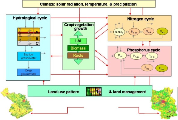
SWIM (Soil and Water Integrated Model) is based on two previously developed models, SWAT (Soil and Water Assessment Tool) and MATSALU. The hydrological module and the vegetation module are basically the same as in SWAT and the nitrogen module was taken from the model MATSALU.
SWIM has a three-level scheme of spatial disaggregation: "basin–sub-basins–hydrotopes". In addition, the root zone can be vertically subdivided into a maximum of 10 soil layers. The hydrotopes are sets of elementary units in a subbasin with homogeneous soil and land use types. It is assumed that a hydrotope behaves uniformly regarding hydrological processes and nutrient cycling. During the simulation: 1) water, nutrients and plant biomass are initially calculated for every hydrotope/every soil layer in a hydrotope level; 2) the outputs from hydrotopes are then integrated to estimate the sub-basin outputs taking retention into account; and 3) the routing procedure is applied to the sub-basin lateral flows of water, nutrients and sediments.
Read more on SWIM.
Nutrient emission model: MONERIS (IGB)
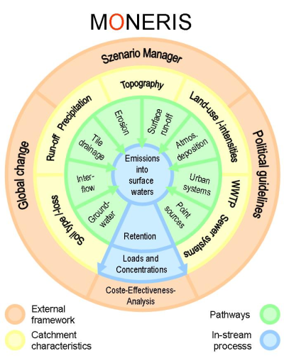
MONERIS (MOdelling Nutrient Emissions in RIver Systems) is a nutrient emission model to be used for regional, national and international studies of water quality in catchment areas. It was developed at IGB-Berlin, to address three goals:
- Identification of the sources and pathways of nutrient emissions at the analytical unit (smallest calculation unit) level
- Analysis of the transport and the retention of nutrients in river systems
- Provision of a framework for examining management alternatives (scenarios)
Since its inception in 1999 MONERIS has been applied to numerous European river systems and river catchments in Canada, Brazil and China. Especially the studies for the Elbe are relevant in an ECONS related context.
Read more on MONERIS.
System of demographic and economic models: REGE (DIW)
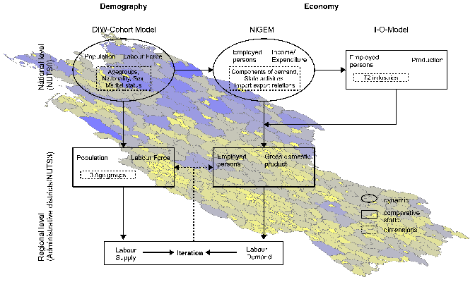
REGE is a system of demographic and economic models used to project socio-economic development at the national and the sub-national level. It is based on various data sources corresponding to the specific information requirements of the individual model components. Starting from the global IPCC-Emissions Scenarios, REGE produces consistent projections of the socio-economic development at the regional scale.
Modeling cascading failures (PIK)
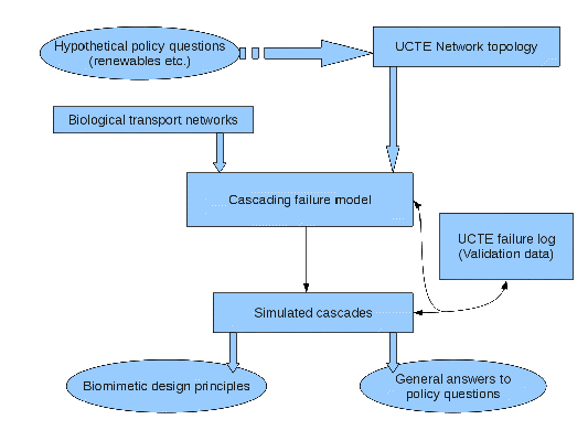
We apply models simulating cascading failures in transmission networks like power grids to intuitively understand the effects of new policy/design decisions on the efficiency and robustness of existing infrastructure. We also look at the outcome of the model when applied on biological transmission networks to learn about interesting network design features that may be of value to infrastructure planners.
|